

Blog
What Government Geospatial Projects Teach Us About Visitor Mapping
Mobiddiction ·
Government geospatial projects are often built for very different audiences than visitor maps.
A surveyor using professional spatial data, a fisheries team publishing regulated boundaries and fishing rules, a public safety agency managing coastal alerts, and a forestry operator working with compliance boundaries all have different needs from a visitor trying to find a toilet, car park, entrance or event stage.
But there is a lot that visitor mapping can learn from government geospatial work.
The same principles that make government maps reliable also make visitor maps better: accurate source data, clear update processes, governed publishing, usable interfaces and long-term support.
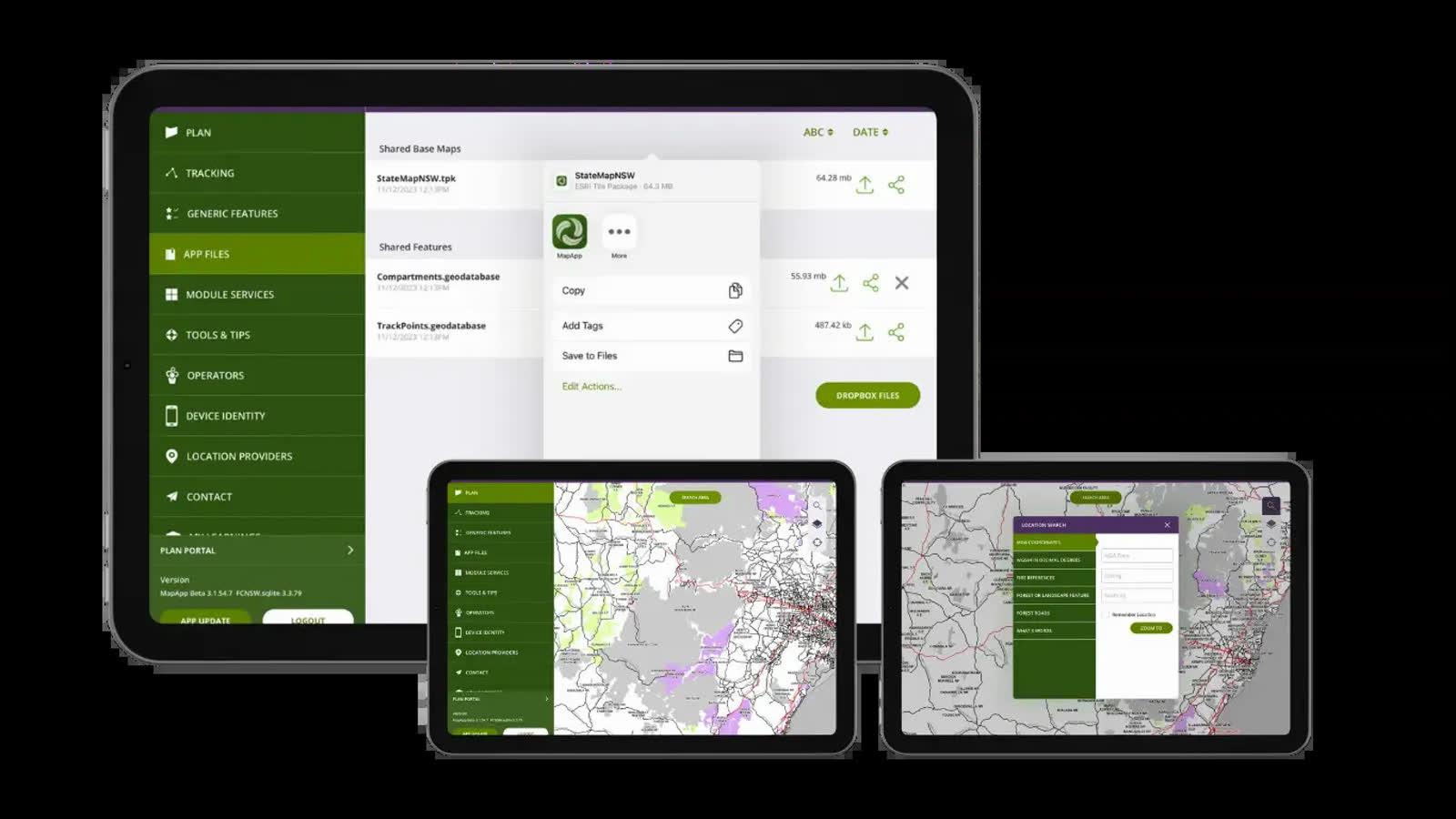
Mobiddiction has worked across government mapping and geospatial programs including NSW Survey Marks, FishSmart, SharkSmart and Forestry Corporation NSW’s MapApp. These projects sit at the more serious end of mapping, where accuracy, trust, workflow and auditability matter.
Those lessons are directly relevant to any organisation that wants to build better digital maps for venues, precincts, events, campuses or public places.
Authoritative Data Matters
NSW Survey Marks is a useful example of why authoritative data matters.
Delivered for NSW Spatial Services, part of the NSW Department of Customer Service, the platform supports access to survey mark and geodetic information used by industry professionals and the public.
This is not just ordinary location information. Survey marks, mark locations and related geospatial data can support professional work connected to land, property, planning and infrastructure. The information needs to be accurate, structured and presented in a way that users can understand.
FishSmart shows a different version of the same principle. Recreational fishers need to understand which rules apply in a specific location. That means the map needs to use accurate spatial data for regulated fishing zones, boundaries and restrictions.
In both cases, the map is only useful if the underlying data can be trusted.
Visitor maps may not always carry legal or regulatory weight, but they still depend on reliable source data. If a venue map shows the wrong gate, the wrong car park, the wrong accessible route or an outdated location, the visitor experience suffers immediately.
Some Maps Carry Legal Or Regulatory Meaning
Not all maps are simply informational.
Some maps help communicate boundaries, restrictions or obligations. In government settings, that can include survey information, regulated zones, public safety areas, operational boundaries or compliance requirements.
FishSmart is a clear example. The map helps users understand fishing rules in relation to their location. A small change in boundary data can affect what a person is allowed to do.
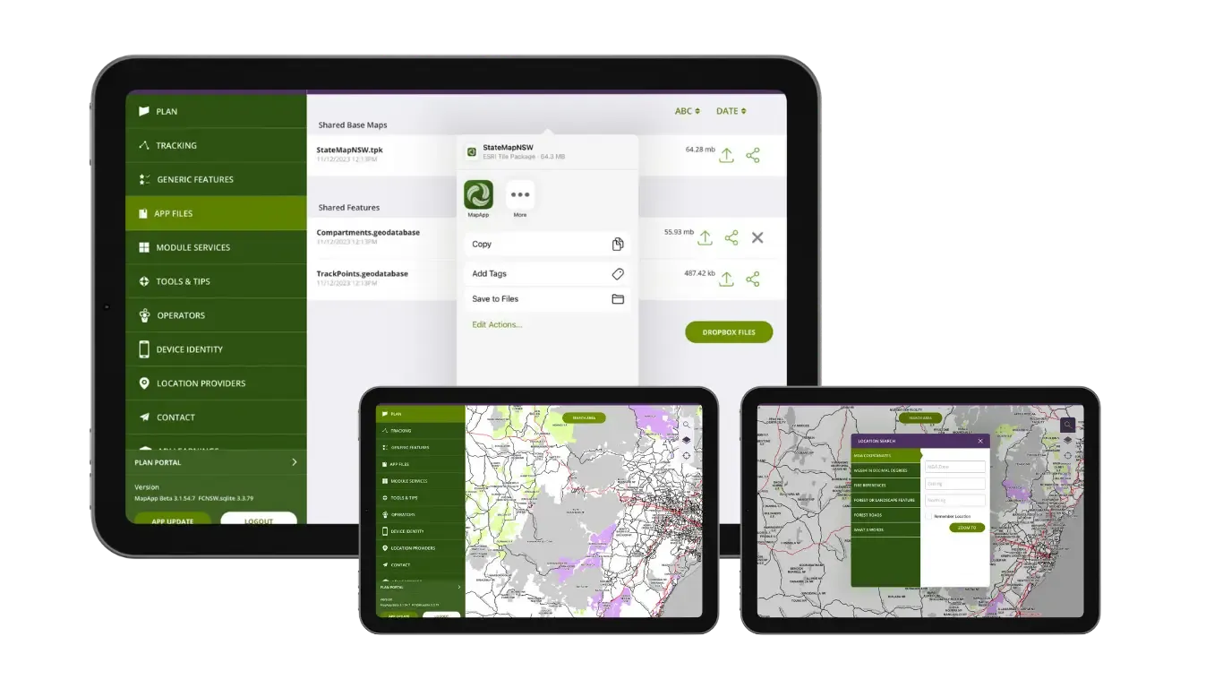
Forestry Corporation NSW’s MapApp is another example. The app integrates with Forestry’s ESRI ArcGIS data and supports field staff working with operational plans, boundaries and planning layers. It also supports compliance-related workflows, including audit logs of location information, tracks and paths taken by harvesting machinery. It provide escalating in-cab boundary warnings as harvesting boundaries are approached, since crossing harvest boundaries by even 1 meter can trigger compliance events, audits, and regulatory penalties.
For field operations, that location history can matter. It can help show where work occurred, where machinery travelled, and how activity related to approved boundaries or operational requirements.
Visitor mapping is usually less regulated, but the lesson still applies. If the map influences behaviour, the data needs to be treated seriously. A route, closure, accessible path or entry point may shape where people go and what decisions they make.
Complex Data Needs A Simple Interface
Government geospatial data can be highly technical, but the interface cannot expect every user to be a GIS specialist.
NSW Survey Marks supports professional and public access to complex geodetic information. SharkSmart brings together shark detections, drone reports, Smart Drumline activity, shark netting information, sightings, incidents and safety alerts. FishSmart helps users understand rules that depend on location and regulated areas.
The job of the digital product is to make that complexity usable.
That does not mean hiding the data. It means structuring it so users can find what they need, understand what they are looking at, and make a decision with confidence.
Visitor mapping has the same challenge. A large venue, event or precinct may have hundreds of points of interest, multiple entrances, temporary changes, accessibility considerations and different user needs. The visitor does not want to interpret raw operational data. They want to know where to go.
A good visitor map takes complex venue information and turns it into a simple, useful interface.
Maps Need Governance And Updates
A map is only useful for as long as it remains accurate.
Government geospatial projects usually need clear ownership, update processes and controls over who can change what. That might include role-based access, validation steps, audit trails, version history or publishing workflows.
That governance is important because geospatial information changes over time. Boundaries are updated. Rules change. assets move. New data sources are added. Operational processes evolve.
Visitor maps need the same mindset, even if the governance model is lighter.
A venue map can become outdated quickly. Tenants move. event layouts change. gates close. paths are blocked. amenities are relocated. construction work affects access. A PDF or static map might remain online long after it stops reflecting the site.
A managed digital map gives organisations a better way to keep information current and publish updates across web, mobile, QR codes, embedded maps or other channels.
Integrations Are Often The Real Work
Many mapping projects are not just map builds. They are integration projects.
NSW Survey Marks involves authoritative spatial data. FishSmart uses Mapbox and Mapbox Studio as spatial sources for fishing rules and boundaries. SharkSmart brings together real-time and near-real-time information from multiple operational sources. Forestry MapApp integrates with ESRI ArcGIS and other Forestry systems.
The visible map depends on the systems behind it.
This is often true for visitor maps as well. A venue might need to connect map data with event schedules, tenant directories, parking information, accessibility data, content management systems, ticketing systems or operational updates.
The map is the interface, but the value often comes from how well it connects to the right information.
Accuracy And Trust Are Operational Requirements
In government geospatial projects, users need to trust the map.
A surveyor needs confidence in spatial data. A fisher needs confidence in regulated zones. A beach user needs confidence in safety alerts. A forestry operator needs confidence in operational boundaries and field data.
Trust is built through data quality, clear workflows, support, monitoring, and ongoing management.
Visitor maps also rely on trust. If a visitor follows a route and it leads to a closed gate, inaccessible path or wrong location, they are less likely to use the map again. If staff know the map is out of date, they stop recommending it.
Accuracy is not a nice-to-have. It is part of the user experience.
Long-Term Support Matters
A map project does not end at launch.
Government and enterprise platforms often need reliable hosting, 24x7 monitoring, feature and security updates, security reviews, support contracts, reporting, new features and ongoing integration work. SharkSmart, FishSmart, NSW Survey Marks and Forestry MapApp all show different versions of long-term mapping support.
That matters because spatial platforms change over time. New data becomes available. Users ask for better workflows. Devices change. APIs change. Operating systems change. Compliance expectations change.
Visitor maps are no different. A venue might start with a public map, then add wayfinding, QR codes, accessible routes, analytics, temporary event layouts, or new integrations over time.
The best mapping projects are designed to evolve.

What This Means For Visitor Mapping
Government geospatial projects teach a clear lesson: the quality of a map depends on more than the visual layer.
For visitor mapping, that means thinking carefully about:
where the source data comes from
who can update the map
how changes are reviewed and published
how users search and filter information
whether the interface is simple enough for non-technical users
how routes and access rules are represented
how the map is kept current over time
what integrations are needed now and later
how the platform is supported after launch
A visitor may never think about any of that. They just want the map to work, that is the point.
From Government Geospatial Platforms To Mapiddiction
Mobiddiction’s government geospatial work has shaped how we think about visitor mapping.
Mapiddiction applies many of the same principles in a more accessible product form: custom maps, structured points of interest, wayfinding, accessible routing, QR code access, website embeds and map publishing for venues, events and precincts.
The audience may be different, but the underlying lessons remain the same. A good map needs accurate data, a clear update process, a usable interface and the ability to grow with the organisation.
Talk to Mobiddiction about mapping and geospatial platforms.
More reading
Mobiddiction news · Mapping
From Wild About Whales to Mapiddiction: The Mobiddiction Mapping Story
Mobiddiction’s mapping story started in 2012 with whale sightings. Before custom venue maps, AI-powered wayfinding , major event maps and precinct navigation, our team built one of its first map-based public programs for NSW National…
Read article
Mobiddiction news · VR
Yash’s Digital Innovation Internship at Mobiddiction
Yash’s digital innovation internship at Mobiddiction: client workshops, SharkSmart and PatientVR, and seeing how a program moves from strategy to delivery.
Read article
Mapping
Why Mobiddiction Builds Mapping Platforms: Since 2012
Since 2012 we have built mapping and geospatial programs for government, events, public safety and field teams. Why the platform behind the map matters.
Read article
Turn the ideas in this article into a working program
We assemble and run Government and Enterprise programs on M4, our multi-tenant platform. Tell us what you are working on.